
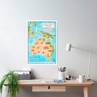
A playful prehistoric megafauna map of Australia, Tasmania and New Guinea which explores in reliable detail a specific slice of deep time.
By drawing on the available science to depict ice age coastlines, rivers, lakes, ocean currents, climate, fauna and the presence of humans, the artwork visualises the past in a fun educational way and challenges a static Australian identity.

Why make this map of prehistoric Australia?
Ten years ago I created a map of the supercontinent Pangaea populated with various creatures that lived in the Triassic. Similar in style to an old sea-faring map with monsters, only the monsters of this time were real. It proved to be popular poster art.
As a professional illustrator with years of experience in educational science illustration I was driven to follow up the map of Pangaea by assembling a map of prehistoric Australia.
The intention was to create an intuitive, engaging way to imagine features of Australia’s past such as land bridges, ancient lakes and ecosystems of vanished enigmatic animals, and to consider the connection of life to climate and a changing terrain. These things have never before been visualised together in one document.
The prehistoric megafauna map of Australia is a serious exploration of the knowledge gathered by expert minds, presented as fun, engaging and educational children’s art.
How was this map made?
There was no existing single visual reference for this map!
To coalesce many fields of science into one image required extensive reading of available knowledge.
I created my own reference guided by scientific literature, topological data and mapping software. Using a referenced estimate of sea levels 65,000 years ago (apparently about 85 metres below present) it was possible to use sea floor data GEBCO 2020 Grid and QGIS mapping software to render a reference map showing the coastlines of a lower sea level. To do this I had to learn to use actual mapping software!
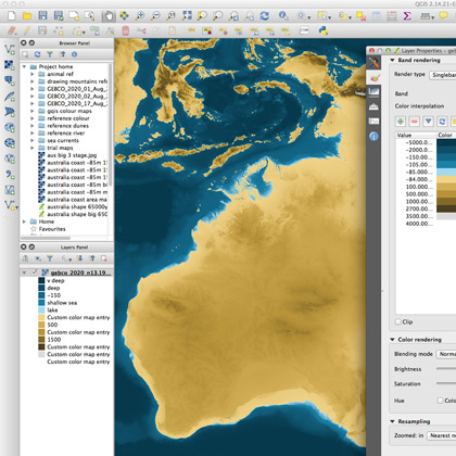 |
| Using sea floor data GEBCO 2020 Grid and QGIS mapping software to reveal Australia's ice age coastline |
The depicted geographical features such as rivers, lakes, mountains, snow lines, areas of vegetation and climate were derived from information gathered from topographical data sets and relevant research papers.
The animals featured were chosen for research suggesting they were still living at the time this map explores. Extinction dates of these animals are uncertain but are likely to have happened after this time period. Except for the Meiolania tortoise. No one knows when this went extinct!
To keep the map clear and un-confusing only large extinct species are featured.
Where possible the animals were based on skeletal reconstructions or diagrammatic reconstructions sourced from relevant research papers, and the latest science describing the animal’s life appearance, posture, etc. Sometimes there were only brief written descriptions or suppositions to go by. Some details are simply made up (ie fur colour) because no one actually knows.
The animals have mostly been placed where they might have lived, though for balance and aesthetics I used some license.
 |
| Over the last 2.4 million years with fluctuating sea levels more often than not the Gulf of Carpentaria has been a lake |
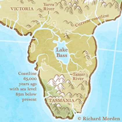 |
| During Glacial Maximums (ice ages) when sea levels are low Australia and Tasmania are connected by a 'land bridge' and Bass Strait becomes a lake |
Meet the vanished megafauna
These creatures lived side by side with the Australian animals we see around us today. With a few notable exceptions most of the megafauna on this map are thought to have gone extinct around 40, 000 years ago.
It was once a land of far greater biological diversity. Sadly we can no longer see these enigmatic giants in real life, though in a few cases this may be for the best. Some of them were terrifying!
So, in order of their appearance on the map...
Meiolania
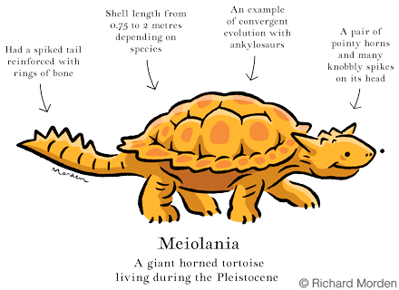
- A giant horned tortoise
- Had a spiked tail reinforced with rings of bone
- Had a pair of pointy horns and many knobbly spikes on its head
- Shell length from 0.75 to 2 metres depending on species
- An amazing example of convergent evolution with ankylosaurs (armoured dinosaurs)
Hulitherium tomasetti

- A giant marsupial living in the mountain rain-forests of what is now the island of New Guinea
- Could probably stand on its hind legs and reach up for juicy leaves
- A browser, preferring soft foliage
- Weighed from 75 kg to 200 kg
Thylacine cynocephalus

- Known as the Tasmanian tiger, yet until a few thousand years ago it lived throughout the entire continent
- Roamed Australia and New Guinea during the Pleistocene only going extinct in the 20th century
- A carnivorous marsupial, carrying its young in a pouch
- An example of convergent evolution, many of its features were strikingly like that of a dog
- Could open its mouth very wide, to around 80 degrees
- Sightings still occur but remain unproven
- Officially declared extinct in the 1980s
Genyornis newtoni

- A giant flightless bird
- Tiny wings and massive, strong legs
- The heavily built beak could be used to apply great force
- Grew to over 2 metres tall and 250 kg
- Related to ducks and geese, but a whole lot bigger
- The last of the mihrungs, a family of giant flightless birds
Phascolonus gigas

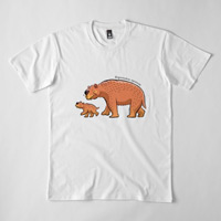
- The biggest species of wombat ever
- Had big square front teeth that grew non stop
- Grew to around 200 kg
- Did it do cube shaped poo like modern wombats?
Palorchestes azael

- An enigmatic giant marsupial
- 1.5 metres at the shoulder and massed 1000 kg
- A slow powerful animal with a strange head and unusual gait
- Strong forelimbs, elbows that could not straighten and chunky claws
- Well developed prehensile lips and a long tongue
Sthenurus stirlingi

- A giant short-faced kangaroo
- Strong heavy build with robust bones
- Grew to between 150 and 200 kg
- Short flat face with forward facing eyes
- Could reach its arms well above its head to pull down tasty leaves
Quinkana
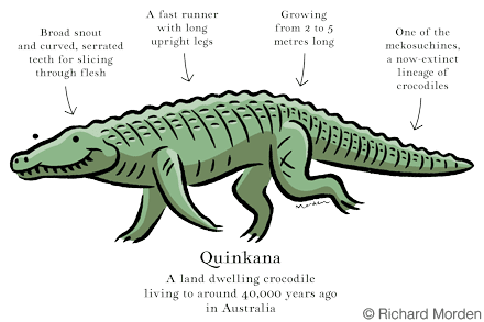
- A land dwelling crocodile
- Broad snout and curved, serrated teeth for slicing through flesh
- A fast runner with long upright legs
- Growing from 2 to 5 metres long
- One of the mekosuchines, a now-extinct lineage of crocodiles
Wonambi
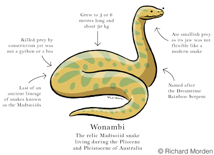
- Last of an ancient lineage of snakes known as the Madtsoiids
- Killed prey by constriction yet was not a python or a boa
- Grew to 5 or 6 metres long and weighed about 50 kg
- Ate smallish prey as its jaw was not flexible like a modern snake
- Named after the Dreamtime Rainbow Serpent
Procoptodon goliah

- A giant short-faced kangaroo
- Big single toe claws like hoofs
- Their anatomy suggests they did not hop. Instead they walked!
- Heavy build, weighing around 200 to 240 kg
- About two metres in height when sitting up
- Short flat face
- Ate tough leaves and stems
- Long arms with two long claws on each hand for reaching leaves
Diprotodon optatum

- The biggest marsupial ever!
- Huge skull filled with air cavities to keep it lighter
- Up to 3 metres long, 2 metres at the shoulder and massing 3000 kg
- Lived in groups and may have been migratory
- Back feet had funny inward turned toes
Zygomaturus trilobus

- A giant diprotodontid living to about 33,000 years ago in Australia
- May have lived in coastal regions near swamps, lakes and rivers
- One of the largest marsupials to have ever lived
- About 1.5 metres at the shoulder and up to 500 kg
- huge cheek bones and a big rubbery nose
Megalania (Varanus Priscus)

- The giant monitor lizard
- By far the biggest terrestrial lizard to have ever lived
- Estimated lengths approaching 5 to 7 metres and massing up to 2200 kg
- Mouth full of large teeth like serrated blades
- Had venom and toxic bacteria in its saliva
Murrayglossus hacketti
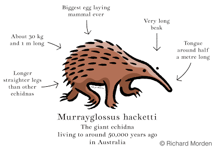
- The giant echidna
- Biggest egg laying mammal ever
- Longer straighter legs than other echidnas
- About 30 kg and 1 m long
- Very long beak
- Tongue around half a metre long
Progura gallinacea
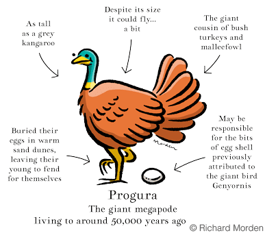
- The giant megapode
- Buried their eggs in warm sand dunes, leaving their young to fend for themselves
- As tall as a grey kangaroo
- Despite its size it could fly... a bit
- The giant cousin of bush turkeys and malleefowl
- Is it responsible for the remains of egg shell previously attributed to the giant bird Genyornis?
Thylacoleo carnifex
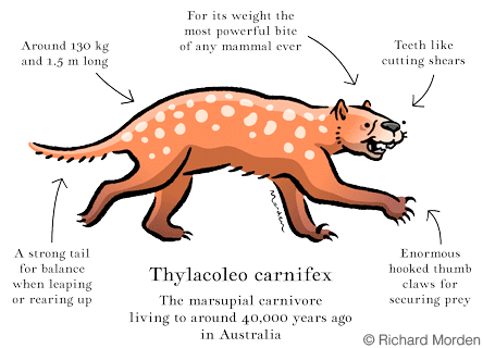
- A huge marsupial carnivore
- Around 130 kg and 1.5 m long
- For its weight the most powerful bite of any mammal ever
- Teeth like enormous cutting shears
- Enormous hooked thumb claws for securing prey
- A strong tail for balance when leaping or rearing up
Protemnodon anak
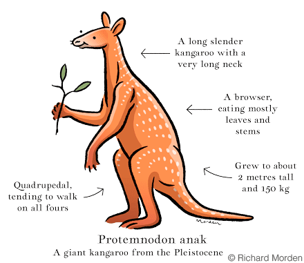
- A slender giant of a kangaroo with a very long neck
- Quadrupedal, tending to walk on all fours
- A browser, eating mostly leaves and stems
- Grew to about 2 metres tall and 150 kg
Want to know more about the giants of Australia’s Pleistocene?
There are many excellent museums and locations around Australia which deliver amazing insights into Australia’s ice age landscapes and life. My personal favourites are
- Naracoorte cave tours and Wonambi Fossil Centre in Naracoorte, South Australia
- Mungo track, tours and visitors center at Mungo National Park, New South Wales
- Melbourne Museums exhibit 600 Million Years, the origin and evolution of life in Victoria
A book about Australian megafauna suitable for all ages with beautiful illustrations:
- Prehistoric Giants : The Megafauna of Australia
written by Danielle Clode published by Museum Victoria 2009
Or if you want to take a deep dive into Australia's Pleistocene climate and ecology a great starting point is searching for topics on Google Scholar
Map sources
To make the Prehistoric megafauna map of Australia required extensive reading of available knowledge. References as follows:
Map projection
Lambert conformal conic projection
Coastal contours
Based on bathymetric data GEBCO 2020 Grid.
Rendered with QGIS for reference
Sea level at 85 meters below present
De Deckker, P., Arnold, L.J., van der Kaars, S., Bayon, G., Stuut, J.B.W., Perner, K., dos Santos, R.L., Uemura, R. and Demuro, M., 2019. Marine Isotope Stage 4 in Australasia: A full glacial culminating 65,000 years ago–Global connections and implications for human dispersal. Quaternary Science Reviews, 204, pp.187-207. https://doi.org/10.1016/j.quascirev.2018.11.017
Mountains
Based on land data GEBCO 2020 Grid
Existing rivers and salt lakes
Australia Report Map Geoscience Australia 2007
Coastal paleo rivers
Harris, P., Heap, A., Passlow, V., Sbaffi, L., Fellows, M., Porter-Smith, R., Buchanan, C. and Daniell, J., 2003. Geomorphic features of the continental margin of Australia. Geoscience Australia, Canberra.
Voris, H.K., 2000. Maps of Pleistocene sea levels in Southeast Asia: shorelines, river systems and time durations. Journal of biogeography, 27(5), pp.1153-1167.
Hill, P.J., De Deckker, P., Von der Borch, C. and Murray-Wallace, C.V., 2009. Ancestral Murray River on the Lacepede Shelf, southern Australia: Late Quaternary migrations of a major river outlet and strandline development. Australian Journal of Earth Sciences, 56(2), pp.135-157.
Murray-Wallace, C.V., 2014. The continental shelves of SE Australia. Geological Society, London, Memoirs, 41(1), pp.273-291.
Paleo lakes
Harris, P.T., Heap, A.D., Marshall, J.F. and McCulloch, M., 2008. A new coral reef province in the Gulf of Carpentaria, Australia: colonisation, growth and submergence during the early Holocene. Marine Geology, 251(1-2), pp.85-97.
Baird, M., 2018. Bass Strait Glider Reveals the Ancient Bassian Lake. Integrated Marine Observing System (IMOS) Ocean Current News
Sand dunes
Hesse, P.P., 2010. The Australian desert dunefields: formation and evolution in an old, flat, dry continent. Geological Society, London, Special Publications, 346(1), pp.141-164.
Climate and vegetation
De Deckker, P., Arnold, L.J., van der Kaars, S., Bayon, G., Stuut, J.B.W., Perner, K., dos Santos, R.L., Uemura, R. and Demuro, M., 2019. Marine Isotope Stage 4 in Australasia: A full glacial culminating 65,000 years ago–Global connections and implications for human dispersal. Quaternary Science Reviews, 204, pp.187-207.
De Deckker, P., Moros, M., Perner, K., Blanz, T., Wacker, L., Schneider, R., Barrows, T.T., O’Loingsigh, T. and Jansen, E., 2020. Climatic evolution in the Australian region over the last 94 ka-spanning human occupancy-, and unveiling the Last Glacial Maximum. Quaternary Science Reviews, 249, p.106593.
Hope, G., Kershaw, A.P., van der Kaars, S., Xiangjun, S., Liew, P.M., Heusser, L.E., Takahara, H., McGlone, M., Miyoshi, N. and Moss, P.T., 2004. History of vegetation and habitat change in the Austral-Asian region. Quaternary International, 118, pp.103-126.
Sea currents
Petrick, B., Martínez-García, A., Auer, G., Reuning, L., Auderset, A., Deik, H., Takayanagi, H., De Vleeschouwer, D., Iryu, Y. and Haug, G.H., 2019. Glacial indonesian throughflow weakening across the mid-pleistocene climatic transition. Scientific reports, 9(1), pp.1-13.
Megafauna living 65,000 years ago
Bradshaw, C.J., Johnson, C.N., Llewelyn, J., Weisbecker, V., Strona, G. and Saltré, F., 2021. Relative demographic susceptibility does not explain the extinction chronology of Sahul’s megafauna. Elife, 10, p.e63870.
Hocknull, S.A., Lewis, R., Arnold, L.J., Pietsch, T., Joannes-Boyau, R., Price, G.J., Moss, P., Wood, R., Dosseto, A., Louys, J. and Olley, J., 2020. Extinction of eastern Sahul megafauna coincides with sustained environmental deterioration. Nature communications, 11(1), pp.1-14.
Presence of modern humans
Clarkson, C., Jacobs, Z., Marwick, B., Fullagar, R., Wallis, L., Smith, M., Roberts, R.G., Hayes, E., Lowe, K., Carah, X. and Florin, S.A., 2017. Human occupation of northern Australia by 65,000 years ago. Nature, 547(7663), pp.306-310.


